INTRODUCTION
The following is a map
(figure 1) representing potential locations for the establishment of a bio-tech
industrial park in the City of Brockton. The potential locations were
determined using data from Massachusetts GIS and the following criteria
provided by the city:
1.
The parcel has
to be at least 10 acres in area.2. The parcel has to be 50 feet from any wetland or waterbody.
3. The parcel has to be already industrial or commercial zoned.
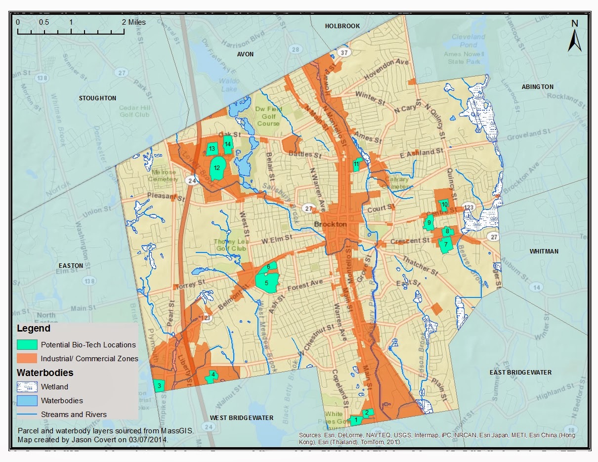
| Figure 1: Potential locations for bio-tech industrial park in Brockton, MA
POTENTIAL PARCEL DATA

RESULTS
After
the set criteria were applied to parcel data for the City of Brockton, fourteen
parcels were found to be potential locations for the establishment of a
bio-tech industry. All are contained within an industrial or commercial zone,
are fifty feet or more from hydrological features, and are over ten acres in
area. While the fourteen highlighted parcels on the map are potential, some are
less suitable than others. For the purposes of identifying each parcel on the
map, they have been assigned a unique number identifier. Potential parcels, 1,
3, 4, 7, 10, 11, 12, and 14 would not be ideal because they are currently
occupied by businesses which have minimal space for construction of new
buildings. Parcel 9 appears to have the most potential as it is a decent sized
parcel, with room for construction, and nearby to Brockton Hospital which will
likely be interested in partnering with new bio-tech firms. Considering the
location relative to the hospital, the area could become considered the
healthcare district of the city which would help it be recognized by new
bio-tech companies. The remaining parcels have similar characteristics, but are
farther from the hospital and have slightly less building area. They would,
however, all serve as good alternatives if problems arose in parcel 9.
ANALYSIS
It
is recommended that further analysis be done to determine what potential
parcels are being used for specifically, who are the owners who may be affected
by any changes, and what is the total value is of the parcel. For the purposes
of this report, the use type shown in Table 1, was determined by looking at
satellite imagery of the parcels. This would help in developing a plan of
action to transform the parcel to a state that would be desirable for bio-tech
companies. Finding the value of the parcel will be required so the city can
determine how much it will cost to buy up the properties if that is deemed
necessary for construction. There are also environmental criteria that should
be considered. Geological analysis may need to be done to determine how
susceptible the area is to groundwater contamination by the new industries.
There are data layers provided by MassGIS that may be of use for this analysis.
Proximity to residential areas may also be an area of concern, and if this is
considered, Parcel 9 may not be an ideal location as it is primarily surrounded
by single family homes.
Given
the size of land necessary for the development of a bio-tech industrial park,
there are alternative options to constructing new buildings on existing
commercial parcels. Buying and renovating buildings already in existence may be
a more cost effective plan for the city to pursue. There is also the option of
reducing the minimum ten acres criteria by constructing a multi-story building.
This would be more space efficient and can accommodate the same amount, if not
more, businesses. By reducing the acreage criteria, there would be more options
for placement of the area.
PROCESS
The
primary tool used to complete this report was ESRI’s ArcGIS software. The
methods that were used are highlighted below in simple steps that will allow it
to be replicated by any town wishing to do the same analysis (Figure 2). The
primary tool within ArcGIS that was used was “select by attributes” and “select
by location.” It will be necessary to select from current selection between
each process step highlighted below. The final layer was produced from the
final selection, which minimized the original parcel amount to the fourteen
which met the criteria established. It may be possible to streamline this
process by creating a script and changing the parameters according to the town
being analyzed in that script. All the data is available for no cost on the
MassGIS website.

|
No comments:
Post a Comment